


Empire Wind’s Shaky Secret
Did Empire Wind intentionally omit vital facts from publicly available official documents concerning a “major fault” beneath a portion of its lease area?

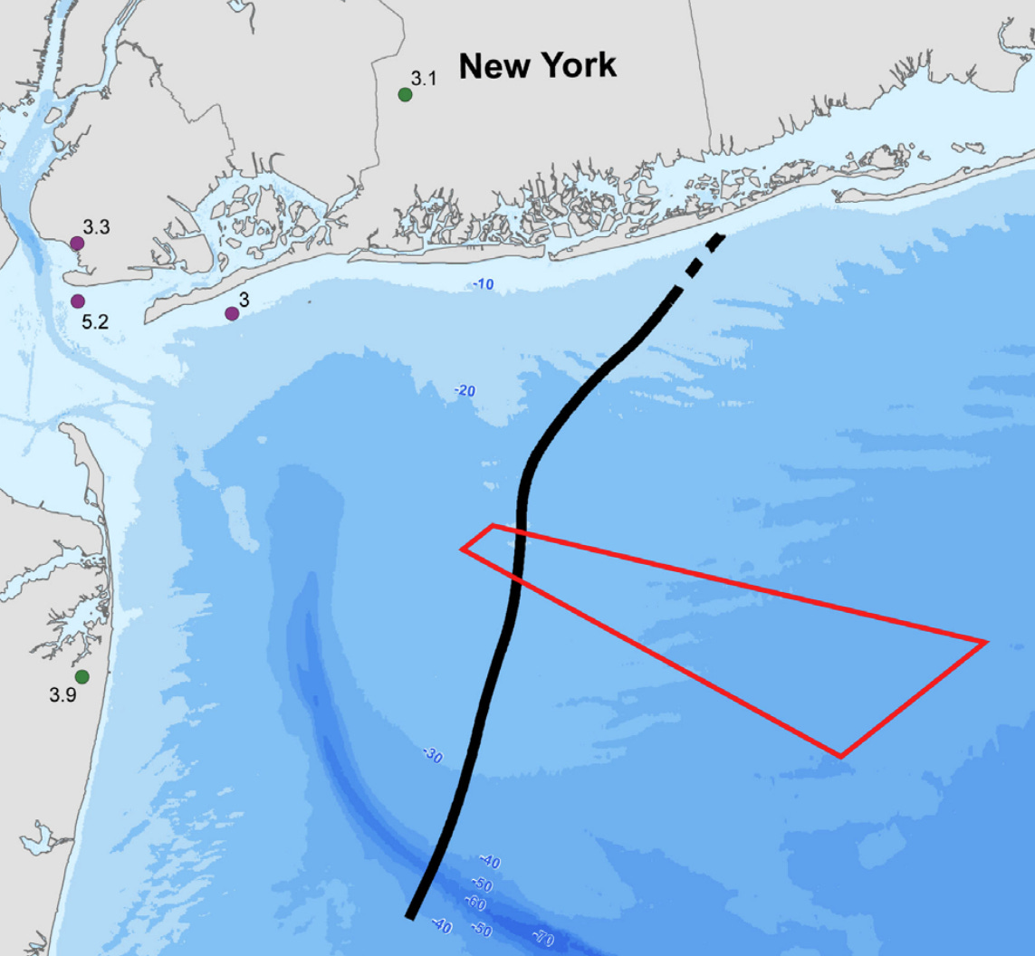
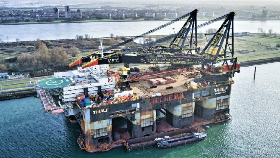
As the enormous crane vessel Thialf arrived from the Netherlands on May 26 to pound monopiles into the seabed for Empire Wind off the coasts of New Jersey and New York, no mention has been made of the fact that a “major fault” runs smack through a portion of its lease area.
Despite reaching out to the Bureau of Ocean Energy Management, Empire Wind, Equinor, and Tetra Tech – the company that produced many of the documents – not a single answer was provided to questions posed by this reporter about the project being located over such a fault. Construction at Empire Wind recently resumed in the wake of the Trump administration rescinding a stop-work order.
However, the New York Bight fault is described in a 2010 “Pre-Development Assessment” report about the lease area prepared by the state of New York as “the largest fault in the region,” with seismic activity in the past “suggesting that the fault may be active.”
The report goes on to say that “The possibility of a seismic event occurring during the project’s operation should be further investigated and may be considered in the design of turbine foundations and other system components.” (See end of this article to download document.)
The Bureau of Ocean Energy Management (BOEM) should be well aware of that particular fault as well.
Referencing that New York report in a 2016 BOEM document, the agency said that the fault “…would need to be considered in the assessment of geologic shallow hazards once a SAP and/or COP has been submitted, as required by BOEM regulations.”
So, was the New York Bight fault “considered” by Empire Wind, and if so, how? Why wasn’t it mentioned in public documents released in the project's site assessment plan (SAP) and construction and operations plan (COP)?
And why are sections in those official papers that address the “geological conditions” concerning Empire Wind heavily redacted, with an entire appendix, an “investigation report” containing information about the “geological conditions within the project area” withheld from public view?
“Seismic events will require further study…”
Long before the Norwegian company Equinor snagged the lease for the project later named Empire Wind, geologists and others were very familiar with the New York Bight fault.
First identified in the early 1980s by Dr. Deborah Hutchinson and Dr. John Grow, who worked at the U.S. Geological Survey, the fault was originally described in a 1982 publication they authored and put out by the U.S. Department of the Interior. As for the potential of seismic activity, the authors said at the time:
Three events (earthquakes) are located within 20 km of the New York Bight fault…the location errors for these three earthquakes probably allow parts of the fault to be located within the epicentral zone. This suggests active seismicity may be occurring very close to, if not actually on, the fault.
In 1985, Hutchinson and Grow published their findings as a more formal research paper, again reaffirming the possibility of seismicity on, or very close to, the fault.
Years later, as offshore wind areas were being formulated off the coasts of New York and New Jersey, the New York Bight fault once again became a topic of interest.
It was thoroughly covered in a 2010 report (see link at bottom) put out by the New York State Energy Research and Development Authority (NYSERDA), which stated: At the west end of the project area lies the New York Bight Fault. The fault formed approximately 95 to 30 million years ago and is at least 50 km (31.1 mi) long trending north-northeast. The fault is potentially active with reports possibly linking it to several past earthquake events.
The NYSERDA report also discussed past earthquake activity in the area, such as the 1884 5.2 magnitude quake that radiated many thousands of miles away from its probable epicenter beneath Brooklyn.
“Seismic events will require further study as the project (Empire Wind) enters later stages of development,” the NYSERDA document said.
But if or how such “further study” was accomplished remains unknown.

The mysterious appendix H
Plowing through the many hundreds of pages of the Empire Wind Construction and Operations Plan reveals little to no information related to earthquake risks in general or the New York Bight fault in particular.
Volume 1 of the COP titled Project Information, does mention several items, such as “shallow hazards” and “faults,” as well as “seismic activity at your proposed site” being a “BOEM requirement” for a COP. However, that information appears in “Appendix H,” which the offshore wind company has kept confidential by not making it available to the public.
Similarly, large sections of Volume 2a, which are said to cover the geological conditions offshore of the project area, are heavily redacted with entire pages blacked out.
But curiously, in the Site Assessment Plan authored by Tetra Tech, it states that “no fault zones, nor any other faulting activity, are identified either from seabed data or from the sub-bottom profiler records…” Both Tetra Tech and Equinor did not respond to questions about what that meant or what part of the project area they had surveyed to get those results.
The bigger picture
When earthquakes are contemplated, California and its famed San Andreas fault typically are what come to mind. Yet the East Coast, including offshore areas such as the New York Bight, is “riddled” with faults, both known and unknown.
Asking geophysicist and seismology expert at Columbia University’s Lamont-Doherty Earth Observatory, Dr. Klaus Jacob, about the risk involved in building giant offshore wind areas in the New York Bight, he offered this: “I wish I would have the confidence that all the hazards, including seismic hazards and tsunami waves…have been considered.”
“The entire East Coast,” said Dr. Jacob, who is a prominent authority in disaster risk management, “is fundamentally prone to earthquakes…which can occur almost anywhere because our coast is so riddled with ancient faults.”
The most “unfortunate situation,” Jacob believes, would be a landslide, such as occurred during a 1929 earthquake centered on the edge of Grand Banks, Newfoundland. That event, which was felt in New York City, triggered not only a tsunami but a giant submarine landslide (underwater movement of sediment) that snapped a dozen trans-Atlantic telegraph cables.
The “probability for such a thing to occur in the functional life of those structures,” according to Jacob, is “probably small, but it’s not zero either.”
If you’re a gambling person, however, the odds look much better for a magnitude 5, 5.5 (or maybe greater) shake fairly soon.
“Taking the historic record in the New York Bight area,” Jacob pointed out, “those (magnitude earthquakes) occur roughly every 100 or 150 years. We haven’t had one since 1884, so it’s now been 141 years.”
And if an event like that—or even worse—should occur sooner rather than later, what precautions have been taken by the companies involved in this project or by the federal agencies overseeing it?
When told that such information had been withheld from public view, Dr. Jacob’s response was, “That is a most regrettable situation and should not be the case.”
Forget the fault line, the area is the most toxic in the world. PCBs from the Hudson and L.I. Sound, dioxins from 9/11, Agent Orange from the manufacturing of it in NJ have all settled there. Whales are the most toxic animals on earth, and are dying because the toxic sediments are being resuspended, entering the food chain. We all have bits of PCB-laced microplastic in our brains, organs, and unborn children, making us sick with diabetes, cancer, and most of what JFK Jr. has identified as making us the sickest people on earth. We are sick if we allow this.
Wow, so they're building this wind farm over a potentially active fault. This is great investigative reporting, hope this travels far and wide!